Articles
South 200 Shopping Center
Park 2000 Shopping Center
LA 61200
Oknoname 113200 Reservoir
Oknoname 017200 Reservoir
2000 Shopping Center
2000 Center
Medicine Creek Reservoir 200
Rivers Edge Gateway 2000 Trail
200 Boylston Street Shopping Center
Gateway 2000 Plaza
The Shops at 2000 Penn Shopping Center
1200 on the Mall Shopping Center
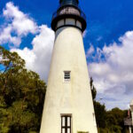
Amelia Island Lighthouse
The Amelia Island Lighthouse is a historic lighthouse located on Amelia Island in Nassau County, Florida. Situated at the northern end of the island, the lighthouse has served as a navigational aid for mariners entering the St. Mary’s River and Cumberland Sound for over 200 years. Constructed in 1838, the Amelia Island Light was the […]