Featured Articles
-

75 Deepest Lakes in the US
The United States have their fair share of deep lakes both natural and man-made. Using a cut-off of 300 feet […]
-
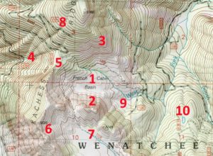
How to Read Topographic Maps
Topographic maps are complicated to say the least. They have a lot going on with different colors, lines, and labels […]
-
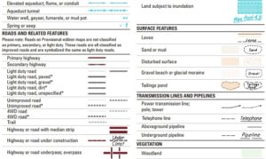
Topographic Map Legend and Symbols
The topographic maps on TopoZone were created by the United States Geological Survey (USGS) and have evolved for more than […]
-
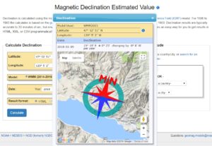
Topo Map Orientation (True North vs Magnetic North)
All of the topographic maps on TopoZone are displayed and printed with true north up. If you are using a […]
-
How to Use GPS Coordinates to Find Topographic Maps
All of the points of interest pages on TopoZone have coordinates (latitude and longitude) in the information section below the […]