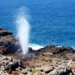
Halona Blowhole Topo Map in Honolulu County HI

Buy This Printed Topo Map

Print map | View map legend

Map Provided by TopoZone.com


Halona Blowhole Information

Coordinates: 21.2823165°N, -157.6763284°W
Approx. Elevation: 3 feet (1 meters)
USGS Map Area: Koko Head
Feature Type: Park


Nearby Parks

Feature USGS Topo Map
The Point Koko Head
Palea Point Koko Head
Kaloko Koko Head
Paioluolu Point Koko Head
Kaihuokapuaa Koko Head
Kawaihoa Point Koko Head
Makapuu Point Koko Head OE E
Sand Point Koko Head
Paiko Peninsula Koko Head
Niu Peninsula Koko Head


Halona Blowhole near Koko Head and Hanauma Bay in eastern Oahu, Hawaii

Halona Blowhole is listed in the Parks Category for Honolulu County in the state of Hawaii. Halona Blowhole is displayed on the "Koko Head" USGS topo map. The latitude and longitude coordinates (GPS waypoint) of Halona Blowhole are 21.2823165 (North), -157.6763284 (West) and the approximate elevation is 3 feet (1 meters) above sea level. If you are interested in visiting Halona Blowhole you can print the free topographic map, terrain map, satellite/aerial images, and other maps using the link above. The location, topography, nearby roads and trails, and towns around Halona Blowhole (Park) can be seen in the layers of this interactive map. If you have already visited Hawaii's Halona Blowhole in Honolulu County, the nearest Parks are listed above for your consideration.