Lehman Caves Information
Coordinates: 39.0055019°N, -114.2202726°W
Approx. Elevation: 6,834 feet (2,083 meters)
USGS Map Area: Lehman Caves
Feature Type: Park
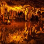
Lehman Caves National Monument is now part of Great Basin National Park in Nevada. Tours are offered to different parts of these historic caves including Lodge Room, Inscription Room, Gothic Palace, Queens Bath, Music Room and Grand Palace the farthest room from the entrance.
Tickets can be booked online through Recreation.gov and they are highly recommended as tours can fill up. The tours typically open in March and end in October.
If you can’t make the drive to remote Nevada to see the caves in person, the Great Basin National Park Service YouTube page has virtual tours which are excellent.
Lehman Caves is listed in the Parks Category for White Pine County in the state of Nevada. Lehman Caves is displayed on the "Lehman Caves" USGS topo map. The latitude and longitude coordinates (GPS waypoint) of Lehman Caves are 39.0055019 (North), -114.2202726 (West) and the approximate elevation is 6,834 feet (2,083 meters) above sea level. If you are interested in visiting Lehman Caves you can print the free topographic map, terrain map, satellite/aerial images, and other maps using the link above. The location, topography, nearby roads and trails, and towns around Lehman Caves (Park) can be seen in the layers of this interactive map. If you have already visited Nevada's Lehman Caves in White Pine County, the nearest Parks are listed above for your consideration.