Crater Lake Information
Coordinates: 42.9420125°N, -122.1063895°W
Approx. Elevation: 6,178 feet (1,883 meters)
USGS Map Area: Crater Lake East
Feature Type: Lake
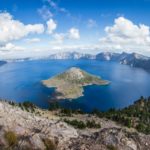
Crater Lake is the deepest lake in Oregon and the deepest lake in the United States. The deepest point in the lake is 1949 feet below the surface. With a surface area of 20.6 square miles (53 Sq km, 13,184 acres) Crater Lake is the second largest lake in Oregon that is not a reservoir. Upper Klamath Lake is the largest lake and its size is regulated by a dam, but it’s not considered a reservoir.
By comparison Crater Lake is the 9th deepest lake in the world, but since the bottom is relatively flat, it’s the 3rd deepest in the world by average depth. The deepest lake in North America is Great Slave Lake in the Northwest Territories, Canada (2015 feet deep or 614 meters).
Crater Lake a natural lake that was formed by the collapse of a huge volcano named Mount Mazama about 8000 years ago. Due to this formation it is a relatively round lake (5-6 miles wide in all directions) and there are no streams flowing through the lake. Mt. Mazama, once about 12,000 feet tall, is dormant and unlikely to erupt any time soon, but it could again someday.
Crater Lake National Park was established in 1902 to protect this lake and its surroundings for everyone to share.

Crater Lake is listed in the Lakes Category for Klamath County in the state of Oregon. Crater Lake is displayed on the "Crater Lake East" USGS topo map. The latitude and longitude coordinates (GPS waypoint) of Crater Lake are 42.9420125 (North), -122.1063895 (West) and the approximate elevation is 6,178 feet (1,883 meters) above sea level. If you are interested in visiting Crater Lake you can print the free topographic map, terrain map, satellite/aerial images, and other maps using the link above. The location, topography, nearby roads and trails, and towns around Crater Lake (Lake) can be seen in the layers of this interactive map. If you have already visited Oregon's Crater Lake in Klamath County, the nearest Lakes are listed above for your consideration.