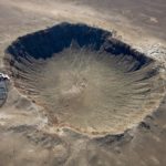
Canyonlands National Park Topo Map in San Juan County UT

Buy This Printed Topo Map

Print map | View map legend

Map Provided by TopoZone.com


Canyonlands National Park Information

Coordinates: 38.18967°N, -109.88606°W
Approx. Elevation: 4,485 feet (1,367 meters)
USGS Map Area: Spanish Bottom
Feature Type: Park


Nearby Parks

Feature USGS Topo Map
Maze Overlook Elaterite Basin
Canyonlands Resort North Six-shooter Peak
Dead Horse Point State Park Gold Bar Canyon
Horseshoe Canyon Unit- Canyonlands National Park Sugarloaf Butte
Kane Springs Picnic Area Kane Springs
Newspaper Rock State Historical Monument Shay Mountain
Old City Park Rill Creek
Moab KOA Moab
Slickrock Country Camp Moab


Canyonlands National Park is listed in the Parks Category for San Juan County in the state of Utah. Canyonlands National Park is displayed on the "Spanish Bottom" USGS topo map. The latitude and longitude coordinates (GPS waypoint) of Canyonlands National Park are 38.18967 (North), -109.88606 (West) and the approximate elevation is 4,485 feet (1,367 meters) above sea level. If you are interested in visiting Canyonlands National Park you can print the free topographic map, terrain map, satellite/aerial images, and other maps using the link above. The location, topography, nearby roads and trails, and towns around Canyonlands National Park (Park) can be seen in the layers of this interactive map. If you have already visited Utah's Canyonlands National Park in San Juan County, the nearest Parks are listed above for your consideration.