Articles
01N37E25BCAC01 Spring
01N03E25CB__01 Spring
Oran 25 Club Lake
D-25 Lake
Buck-Doe Run Watershed Lake Number 25
Berndt Lake NE SE Section 25
School Number 25
Highway 250 Campground
Center 250 Shopping Center
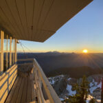
Mount Pilchuck
Mount Pilchuck is a peak located in the North Cascades. With an elevation of approximately 5,300 feet, it offers panoramic views of the surrounding landscapes, making it a popular destination for outdoor enthusiasts and nature lovers. The mountain holds historical significance, as it was once an important landmark for indigenous tribes like the Snohomish and […]
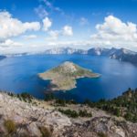
75 Deepest Lakes in the US
The United States have their fair share of deep lakes both natural and man-made. Using a cut-off of 300 feet (91.5 meters) there are at least 75 lakes and reservoirs that meet or exceed that depth. Three of the US lakes are among the top 25 deepest in the world. There is quite a variety […]
City of Arches Hike
This hike features many different lava rock arches along the shoreline north of Honaunau Bay on the Big Island. It can be done as an out-and-back or a loop but either way you park near the Two Step snorkeling spot on the bay. Along the way this hike passes by Miana Point and Pehehoni Point […]
The Wave Photography Spot
Photo by Rick McCharles This is the location of the photos you’ve seen of “The Wave” with red sandstone waves and perfect lines following the eroded contours. It’s a dramatic spot and is surrounded by other photographic geologic rock formations like the Mini Wave, the Second Wave, Sand Cove, Melody Arch, Boneyard, The Alcove, North […]
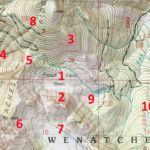
How to Read Topographic Maps
Topographic maps are complicated to say the least. They have a lot going on with different colors, lines, and labels all over the place. The land survey information is a good example. While most topo map users aren’t reading the township, range, and section information, it is still on the maps. Another example is that […]