The summit of Mount Whitney at 14,505 feet (4421 meters) of elevation is the highest mountain in California and the 48 contiguous United States. It rises steeply from the town of Lone Pine in the Owens River Valley and is said to have a prominence of 10,075 feet or nearly two miles! Hikers and backpackers […]
Read full post »
The United States have their fair share of deep lakes both natural and man-made. Using a cut-off of 300 feet (91.5 meters) there are at least 75 lakes and reservoirs that meet or exceed that depth. Three of the US lakes are among the top 25 deepest in the world. There is quite a variety […]
Read full post »
The Estherville Meteorite hit the Earth 482 feet west of these coordinates on May 10th, 1879. The large meteorite which broke into three pieces, was examined and found to include various metals including one not known to Earth (and subsequently named Esthervillite). Museums around the world now house the meteorite pieces. The impact crater was […]
Read full post »
The Fortune Creek 4×4 Trail starts on the main road that continues beyond Salmon la Sac (NF-4330) and then follows Fortune Creek Road (NF-621) for about three very slow and rough miles. Then the trail turns right and follows the South Fork of Fortune Creek up to Gallagher Head Lake. This is a moderately difficult […]
Read full post »
Moon House Ruin has become one of the best-known ruins on Cedar Mesa and for good reason as it might be the finest ruin in the area (Citadel Ruin wins for best location). Moon House located in upper McLoyd Canyon and visitation is now limited. Stop in at the Kane Gulch Ranger Station to inquire […]
Read full post »
This incredible narrow rock peninsula in Road Canyon on Cedar Mesa is the location of now discovered Citadel Ruin. This ruin is the “Peninsula House” in David Robert’s book about the Anasazi called In Search of the Old Ones. The route to the the peninsula is a bit tricky and changes over time. There’s a […]
Read full post »
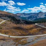
Georgia Pass – See images below of more epic passes Colorado has more driveable passes over 10,000 feet than any other state. Many are not paved making the trip over them more rewarding and in some cases quite challenging! This map locates the Colorado backroads that expose you to thin air at high elevations, rugged […]
Read full post »
Driving the Oregon Coast in the summer is a popular thing to do. So much so that the hotels and motels in the small towns along the route will be completely booked well ahead of time. It’s a beautiful drive with so many places to discover, so plan ahead if you want to make this […]
Read full post »
The National Park Service just released visitation figures from 2015. In total, our national parks saw 307,247,252 recreation visits, up nearly 5% over 2014. Total overnight stays in park campgrounds and the backcountry were up 6% over 2014 and tent camping in particular was up 13%. Here are the top 10 most visited parks. All […]
Read full post »

Here is a map of the volcano that is currently erupting in the Eastern Aleutians region of Alaska. As of March 28th it was spewing ash 37,000 feet into the atmosphere. This ash cloud is affecting air traffic through the region. Pavlof Vocano Topographic Map
Read full post »
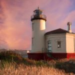
Cape Blanco Lighthouse at dusk
Read full post »
Tillamook Rock Lighthouse is a historic building constructed on Tillamook Rock off the coast from Seaside and Cannon Beach, Oregon. The light was lit on January 21st, 1881 just a few days too late to save a ship that sank near the rock. At the time it was the most expensive lighthouse built on the […]
Read full post »