Neahkahnie Mountain Map
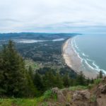
Neah-Kah-Nie Mountain on the Oregon Coast is a popular hike with rewarding views. This trail crosses over the mountain making a point-to-point hike possible with a shuttle vehicle. Most will just hike it as an out-and-back from one of the trailheads. Either way, if you make it to the summit you’ll have views to the […]