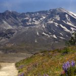
North Fork Toutle River Topo Map in Cowlitz County WA

Buy This Printed Topo Map

Print map | View map legend

Map Provided by TopoZone.com


North Fork Toutle River Information

Coordinates: 46.327889°N, -122.7167777°W
Approx. Elevation: 443 feet (135 meters)
USGS Map Area: Toutle
Feature Type: Stream


Nearby Streams

Feature USGS Topo Map
South Fork Toutle River Toutle
Studebaker Creek Toutle
Outlet Creek Toutle
Wyant Creek Toutle
Hemlock Creek Toutle
Johnson Creek Toutle
Jordan Creek Toutle
Brownell Creek Toutle
Rock Creek Silver Lake
Cedar Creek Eden Valley


North Fork Toutle River is listed in the Streams Category for Cowlitz County in the state of Washington. North Fork Toutle River is displayed on the "Toutle" USGS topo map. The latitude and longitude coordinates (GPS waypoint) of North Fork Toutle River are 46.327889 (North), -122.7167777 (West) and the approximate elevation is 443 feet (135 meters) above sea level. If you are interested in visiting North Fork Toutle River you can print the free topographic map, terrain map, satellite/aerial images, and other maps using the link above. The location, topography, nearby roads and trails, and towns around North Fork Toutle River (Stream) can be seen in the layers of this interactive map. If you have already visited Washington's North Fork Toutle River in Cowlitz County, the nearest Streams are listed above for your consideration.