Articles
The United States have their fair share of deep lakes both natural and man-made. Using a cut-off of 300 feet (91.5 meters) there are at least 75 lakes and reservoirs that meet or exceed that depth. Three of the US lakes are among the top 25 deepest in the world. There is quite a variety […]
Read full post »
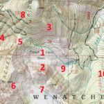
Topographic maps are complicated to say the least. They have a lot going on with different colors, lines, and labels all over the place. The land survey information is a good example. While most topo map users aren’t reading the township, range, and section information, it is still on the maps. Another example is that […]
Read full post »
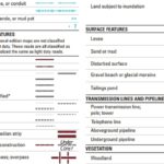
The topographic maps on TopoZone were created by the United States Geological Survey (USGS) and have evolved for more than a century. Over time the maps became more detailed and new symbols were added for the different terrain, natural features, land boundaries, and man-made structures depicted by the surveyors. This legend is now a complex […]
Read full post »
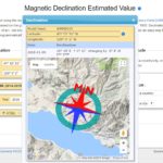
All of the topographic maps on TopoZone are displayed and printed with true north up. If you are using a compass in the field to navigate using a topo map you’ll need to know the “declination” of magnetic north (where your compass will point) and true north (straight up on printed topo maps). Knowing the […]
Read full post »
All of the points of interest pages on TopoZone have coordinates (latitude and longitude) in the information section below the topo map. For example, see the “Coordinates” under the topo map of Hex Mountain. Those coordinates can be entered into a GPS as a destination waypoint. TopoZone uses the WGS84 datum and most GPS units […]
Read full post »
Feature types on TopoZone are used to categorize all the points of interest in our database. These feature types come from the United States Geological Survey (USGS) and are far from perfect. You’ll notice in the list below that there is some overlap of points of interest that fall under different categories. In a few […]
Read full post »
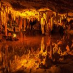
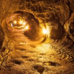
Hell is metaphorically described as a horrific location underground. And while we know this isn’t true, areas underground are dark and eerie enough to seem hellish (but much colder!). The photo above is of Mirror Pond in Luray Caverns which resembles some artists’ depictions of a mythical hell. Crystal Cave If you’ve ever been inside a cavern, […]
Read full post »
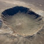
Impact craters are created when an object flying through space impacts the surface of a larger body (a planet or moon). The Moon, which has almost no atmosphere, is covered with impact craters so large and well-preserved that they are visible from Earth. Our planet has few that are easy to see from the surface […]
Read full post »
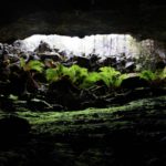
Lava tubes are a type of cave created by molten volcanic lava. For that reason these caves are found in areas of past or present volcanism. Hawaii has many lava tubes to explore as it’s one of the most active volcanic lands on the planet. The western states, which have hundreds of volcanoes and cinder […]
Read full post »
Before heading out to explore a cave or lava tube, make sure you have all you’ll need at the car and with you for the trip. This packing list is for a day-trip that is not steep or technical (no ropes needed). A light source and backup lights (headlamps are best to avoid head injuries) […]
Read full post »
Trees often live longer than us humans, but the oldest individual living trees on the planet currently are just several thousand years old. The oldest species in the US are hardy Great Basin bristlecone pines located in and around Ancient Bristlecone Pine Forest in the California White Mountains and giant sequoias located in Sequoia National Park. If […]
Read full post »

The pinnacle of all castles in America has to be Hearst Castle on the central coast of California. It is truly jaw-dropping even when compared to many much older castles scattered about Europe. If you haven’t taken a tour at Hearst San Simeon State Historical Monument, then add it to your bucket list now. Having seen […]
Read full post »
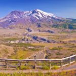
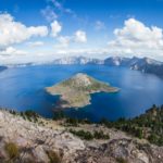
Most Washingtonians know the five main volcanoes in their state, Rainier et al. Each is visible from somewhere along the Interstate 5 corridor, the main north-south route west of the Cascade Mountain Range. But when we were researching volcanoes in Washington we were surprised to discover that there are many more. Several have been active […]
Read full post »
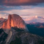
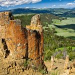
Rock domes are in and of themselves unique, but we wanted to find the most unique domes in the country. Almost everyone has seen or taken pictures of iconic Half Dome as it stands tall in one of the most popular national parks in the US. But there are many other geologically created domes around […]
Read full post »
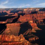
Grand Canyon in Arizona is one of the seven natural wonders of the world. It stands out as the grandest canyon on the planet, not just the United States. Yet the US has many outstanding canyons, valleys, gorges, and gulches. So which are the grandest canyons in America? Rafting in Hells Canyon We set out […]
Read full post »